Evacuations are ongoing in Sindh as Cyclone Biparjoy advances toward the province’s coastal belt on Tuesday.
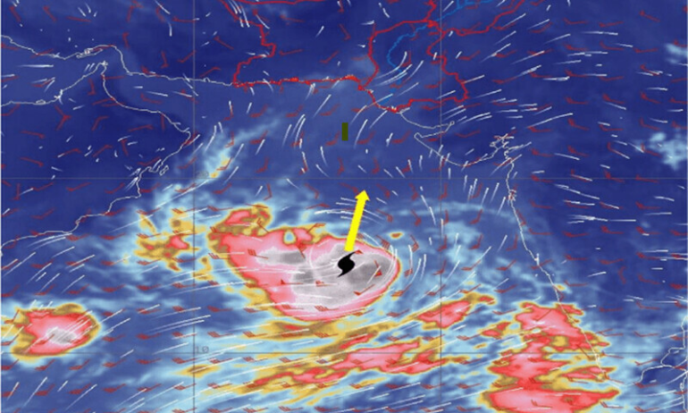
The Pakistan Meteorological Department’s Tropical Cyclone Warning Centre has issued an alert, stating that the cyclone has moved further north-northwestward and is currently located approximately 380km south of Karachi and 390km south of Thatta.
The cyclone is accompanied by maximum sustained surface winds of 150-160km/hour, with gusts up to 170km/hour near its center. Sea conditions are reported to be phenomenal, with maximum wave heights of 30 feet. The favorable environmental conditions are expected to sustain the cyclone’s strength throughout the forecast period.
According to the alert, the cyclone is likely to track further northward until the morning of June 14 (Wednesday), and then recurve northeastward, crossing between Keti Bunder and the Indian Gujarat coast on the afternoon/evening of June 15 as a “very severe cyclonic storm” with winds of 100-120km/hour, gusting up to 140km/hour.
The forecast indicates that Thatta, Sujawal, Badin, Tharparkar, Mirpurkhas, and Umerkot are expected to experience widespread wind, dust, thunderstorm rain, with some very heavy to extremely heavy falls, accompanied by squally winds of 80-100km/hour gusting up to 120km/hour between June 13-17.
Karachi, Hyderabad, Tando Mohammad Khan, Tando Allahyar, Shaheed Benazirabad, and Sanghar districts are also likely to experience dust, thunderstorm rain with a few heavy falls, and squally winds of 60-80km/hour from June 14-16.
The alert warns of a storm surge of 3-3.5 meters at the point of landfall, Keti Bunder, and its surrounding areas, which could lead to the inundation of low-lying settlements. Fishermen are advised not to venture out into the open sea until the system subsides by June 17.
The sea conditions along Sindh’s coast are expected to be very rough to high, with a storm surge of 2-2.5 meters. Similar conditions are anticipated along Balochistan’s coast, covering Sonmiani, Hub, Kund Malir, Ormara, and surrounding areas, with a storm surge of two meters.
Additionally, the Hub and Lasbela districts of Balochistan may experience dust, thunderstorm rain with isolated heavy falls from June 14-16.
Climate Change Minister Sherry Rehman said, in a tweet, that dust storms had already begun on the Hyderabad-Karachi highway, urging the public to stay safe.
She emphasized that the cyclone was veering northeast and remained on course to hit Keti Bandar and the Sir Creek area.
National Disaster Management Authority (NDMA) Chairman Lt Gen Inam Haider Malik told the media that the intensity of Cyclone Biparjoy had increased, and an emergency has been declared in all vulnerable areas.
He warned of the potential impact along the coastline and mentioned the possibility of thunderstorms in Karachi.
The NDMA had initiated the evacuation of 100,000 people from vulnerable areas, with completion expected by the morning of June 15, he noted.
Minister Rehman highlighted the likelihood of high-velocity winds and heavy rainfall causing damage, even if the cyclone did not make a direct hit on Pakistan’s coastline.
The minister called for caution due to the unpredictable nature of the situation.
As of Tuesday night, a total of 56,895 people have been evacuated from Badin, Sujawal, and Thatta districts in Sindh, with 22,260 being voluntary evacuations. The vulnerable population in these areas amounts to 71,380 individuals.