The National Disaster Management Authority (NDMA) has issued a warning urging the public to avoid coastal lines as Cyclone Biparjoy approaches the coastal areas of Pakistan and India.
The cyclone is expected to intensify over the next 24 hours, with southern and south-eastern parts of Sindh likely to be impacted on June 13, the NDMA warned on Sunday.
The NDMA cautioned that the cyclone could bring strong winds, heavy rainfall, and potential flooding to coastal regions. People are advised to stay informed about weather conditions and refrain from going to the beach, while fishermen should avoid venturing into the open sea.
The NDMA emphasized the importance of following guidance from local authorities during emergency situations.
In response to the cyclone threat, the Karachi commissioner has implemented a ban on beach access, fishing, sailing, swimming, and bathing within Karachi’s territorial limits.
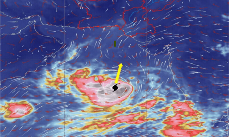
According to the Pakistan Meteorological Department (PMD), Cyclone Biparjoy has intensified into an “extremely severe cyclonic storm” and is currently situated approximately 760km south of Karachi, 740km south of Thatta, and 840km southeast of Ormara.
The PMD forecasts that the cyclone will continue to move northward until the morning of June 14 before recurving northeastward. It is expected to make landfall between Keti Bandar in southeast Sindh and the Indian Gujarat coast on June 15 as a “very severe cyclonic storm.”
The cyclone’s maximum sustained surface winds are recorded at 150-160km per hour, with gusts reaching up to 180km/h. Sea conditions are described as “phenomenal” near the cyclone’s center, with a maximum wave height of 35-40 feet.
The PMD advises residents of Thatta, Sujawal, Badin, Tharparker, and Umerkot districts to prepare for widespread wind, dust, and thunderstorm activity, accompanied by heavy rainfall from June 13-17.
In Karachi, Hyderabad, Tando Muhammad Khan, Tando Allayar, and Mirpurkhas districts, similar conditions are expected from June 13 or 14 to 16, albeit with slightly less intensity.
Squally winds of 80-100km/hour could cause damage to vulnerable structures, while a storm surge of 3-3.5 meters is anticipated at the land-falling point. Fishermen are advised not to venture into the open sea until the system dissipates by June 17 due to anticipated rough sea conditions and high tides along the coast.
Sindh Chief Minister Murad Ali Shah assured the public that the government is fully prepared to handle the potential impact of the cyclone.
The cyclone’s shift away from Karachi’s route is now expected to affect areas such as Thatta, Badin, Sujawal, Badin, Tharparkar, and parts of the Indian state of Gujarat.
The authorities have alerted commissioners of these districts and are coordinating with the Pakistan Army for possible evacuations. Vulnerable families, totaling 8,000-9,000, have been identified, and safe areas are being prepared for their relocation.